


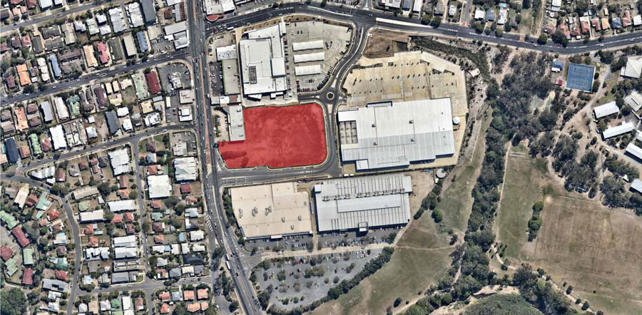
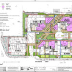
The densification of Brisbane’s middle ring suburbs continues into 2018 with a development application submitted for a new urban village located on a vacant site at 35 Woolworths Street, Everton Park.
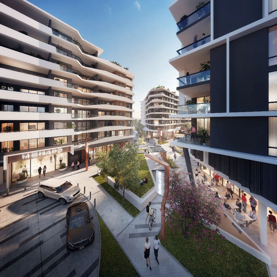
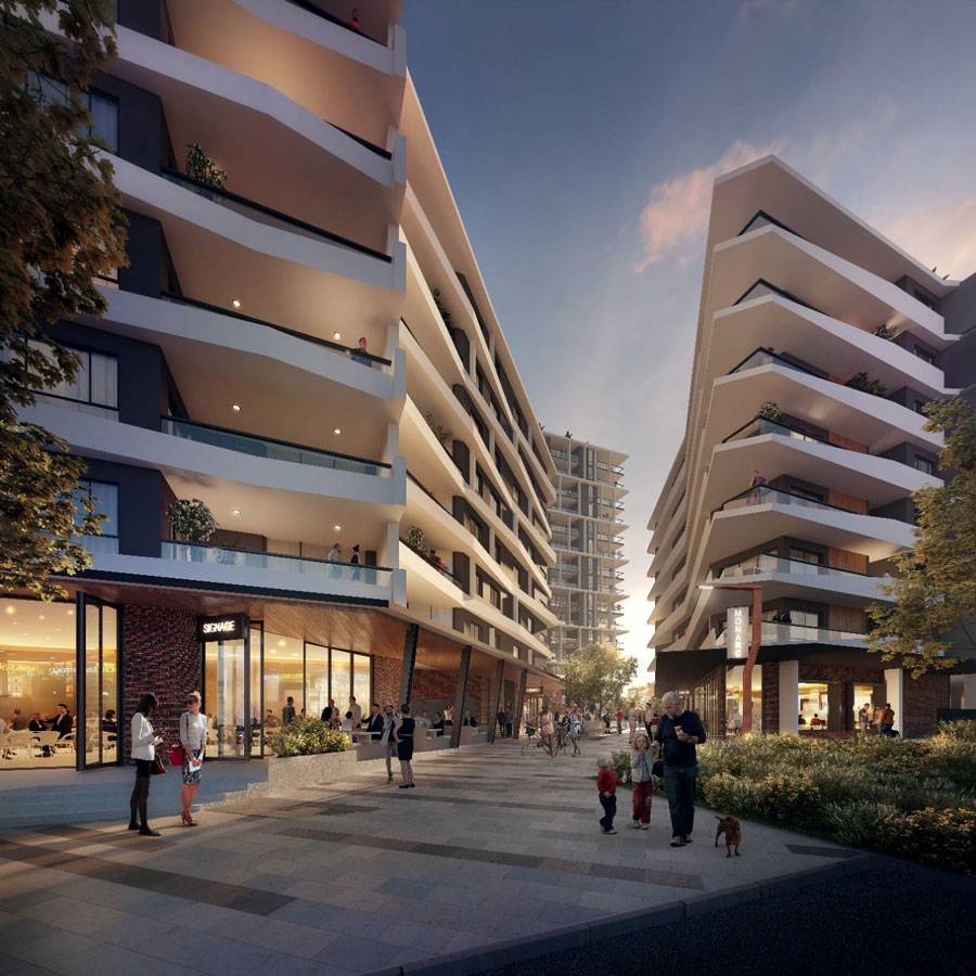
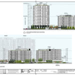
Proposed by Brisbane-based Rogerscorp and designed by Think Tank Architects, the project is a sizable five-stage urban village style development comprising of 378 residential apartments. Stage 1 is proposed to be a three to four-storey commercial building and stages 2, 3, 4 and 5 are residential focused buildings with ground level retail use, configured over 9 to 16 storeys.
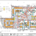
Development Stage 1 (contained within proposed lot 3)
Stage 1 comprises of the construction of three to four-storey mixed-use building over two basement parking levels. The proposed use of this commercial building is for a 636 sqm medical centre, pharmacy, two-level child care centre as well as other ground floor food and retail tenancies.
Development Stage 2 (contained within proposed lot 1)
Stage 2 comprises of a 9-storey mixed-use building over basement car parking. The 9 storeys will have 4 ground level of retail tenancies, 7 levels of residential apartments and a 578 sqm rooftop recreation deck including swimming pool.
- x7 one bedroom apartments
- x56 two bedroom apartments
- x7 three bedroom apartments
- x70 apartments total
70 wall mounted bicycle racks in the basement are planned for residents and a dedicated bicycle storage area at the ground floor level to allow for 3 retail bicycle spaces and 16 visitor bicycle spaces for visitors.
Development Stage 3 (contained proposed lot 2)
Stage 3 comprises of a 9-storey mixed-use building over basement car parking. The 9 storeys will have 3 ground level of retail tenancies, 7 to 8 levels of residential apartments and a 567 sqm rooftop recreation deck including swimming pool.
- 7x one bedroom apartments
- x72 two bedroom apartments
- x8 three bedroom apartments
- x87 apartments total
87 wall mounted resident bicycle racks are planned for the basement as well as a dedicated bicycle storage area at the ground floor level to allow for 2 retail bicycle spaces and 22 visitor bicycle spaces for visitors.
Development Stage 4 (contained proposed lot 4)
Stage 4 comprises of a 16-storey mixed-use building over basement car parking. The 16 storeys will have two ground floor retail tenancies, 13 levels of residential apartments as well as a 738 sqm rooftop recreation deck including swimming pool.
- x13 one bedroom apartments
- x91 two bedroom apartments
- x13 three bedroom apartments
- x117 apartments total
The proposal also provides for bicycle spaces including 179 wall mounted bicycle racks in the basement for residents and a dedicated bicycle storage area at the podium level to allow for 2 retail bicycle spaces and 29 visitor bicycle spaces for visitors.
Development Stage 5 (contained within proposed lot 5)
Stage 5 comprises of a 16-storey mixed-use building over basement car parking. The 16 storeys will have two ground-level retail tenancies, 13 levels of residential apartments and a 513 sqm rooftop recreation deck including swimming pool.
- x13 one bedroom apartments
- x78 two bedroom apartments
- x13 three bedroom apartments
- x104 apartments total
The proposal also provides for bicycle spaces including 104 wall mounted bicycle racks in the basement for residents and a dedicated bicycle storage area at the podium level to allow for 2 retail bicycle spaces and 12 visitor bicycle spaces for visitors.
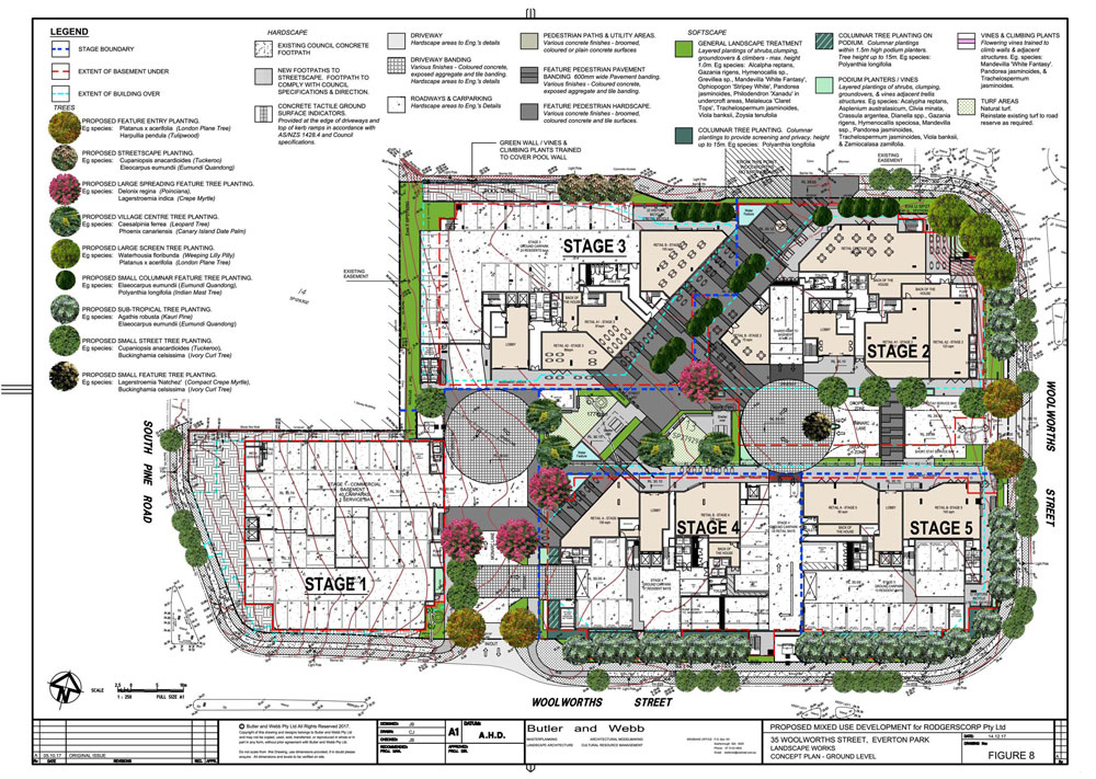
The proposal provides for a public plaza centrally within the development which is of a regular rectangular shape that is also accessed by a dedicated pedestrian link adjacent to the northern boundary. This link connects to the walkway in the Woolworths shopping centre site to the north which is provided in front of the retail tenancies within that shopping centre.
According to the development application:
The development will provide for a vibrant precinct which transforms the site and acts as a catalyst for the future growth of Everton Park and the surrounding commercial area. The development presents for a tangible public benefit with a well rationalised urban design outcome that creates a place for measurable interaction for the local community. – DA Submission

The North West Transportation Corridor
This proposal, as well as many other developments occurring in the North West of Brisbane, raises the issue of the North West Transportation Corridor when strategising ways of catering for population growth in this area of Brisbane. Also known as the ‘Trouts Road Corridor’, this little-known passageway of vacant land was originally set aside for a North Western freeway in the 1960’s running between the Brisbane CBD and Aspley via the Grange and Everton Park.

While the freeway concept was abandoned in the 1970s, this section of the original freeway corridor was kept for future use as an arterial road. However, In recent years, as town planning methods improved, the corridor has evolved from a motorway project to an integrated transport corridor that caters for rail, walking, cycling and road.
Transport blog BrizCommuter has suggested the following strategy for the North West Transportation Corridor which would tie into Cross River Rail.
- The Cross River Rail tunnel would ideally be routed towards a tunnel portal north of Alderley, with a station at Kelvin Grove. As with any tunnelling, this would be very expensive, but opens up a new catchment to rail travel.
- Three tracks would ideally be required along the Trouts Road corridor (peak direction express track for Sunshine Coast/Caboolture services to overtake local Strathpine to City services). Few property resumptions would be required, as this is a reserved transport corridor. It would open a huge new catchment to rail travel.
- An additional track would be required between Strathpine and Petrie, along with a grade separated junction and reversing facilities at Strathpine.
Assumptions: Assumptions are made that Caboolture/Sunshine Coast/Strathpine local services would use the Trouts Road Corridor, Kippa-Ring/Shorncliffe would use one of the existing track pairs between Northgate and the CBD, and Airport/Doomben/(Ferny Grove) would use the other existing. ERTMS signalling would allow for up to 24tph on each track.
Benefits: This plan would considerably increase overall network capacity, would significantly decrease peak and off-peak journey times for Sunshine Coast/Caboolture Line commuters travelling to the CBD, and would provide a huge expansion of the rail network with new stations around Kelvin Grove, Everton Park, Flockton Street, Hamilton Road, Albany Creek Rd, and Carseldine (West).
The development application number for this project is A004827100.


Looks marvellous….hopefully good for jobs too…but….that’s a LOT of cars & therefore commuters it brings to an area that already suffers from major gridlock at peak hour. 2 lanes in/out right there that just sit for ages…. If the North West travel corridor can be made to link with the Cross river rail, that seems great for everyone in the local area and outwards. If it can’t, then it seems like a traffic issue in sheep’s clothing.
Look. Traffic on South Pine Road is already stuffed. People are traveling from Eatons Hill via Old Northern Road now which is also stuffed. South Pine Road Becomes Old Northern Road. Is the Northern Corridor going to fix this? How? Enoggera rail station car park was over flowing at least 10 years ago. Kelvin Grove Road is also Stuffed. I don’t see the northern corridor fixing this and the development in Everton Park (or is it Car Park) will make it worse. Tim Mander said he will fix the problem. If this development goes ahead the problem will only get bigger. I’m so glad I travel away from the city to work.
The North West Transport Corridor, it is seriously a no brainier and it should be a tunnel. The north west is a hot spot for land development right now. At current roads like South Pine Road are feeling the effects of these outer developments as there is little to no public transport… Why they consider such high density developments when there is no transportation within reasonable walking distance is beyond me. Busses don’t count if they’re not a buss way.
Not to mention, this location is right near a school zone which only causes more car parks.
I think it is a great idea but the Transportation Corridors need to be put in place first. I would also like to think that more commercial and office space will be built to provide more localised employment opportunities hence easing the need for more public Transport which is already failing.